![]()
| LINKS PAGE |
CURRENT WEATHER AROUND THE BRITISH
ISLES |
CURRENT WEATHER AROUND THE BRITISH ISLES
UK RAINFALL RADAR
http://www.bbc.co.uk/weather/uk_radar.shtml
The
Latest
Weather
from the
UK Met.Office
UK
and Irish TAFs and METARs
from
the Met Office
Please note that UK TAFs and METARs are made available via
The Met. Office site, with registration, subject to the conditions
of use for these products. European TAFs and METARs are available from
the MetWEB
service.
UK weather reports from NWS
Latest UK
Synop
Latest Scandinavian
Synop
(Links to the
Top Karten site)
Weather
reports (Metar) from the University of Wyoming
Meteorological
Station Information Lookup
You will
need the
4-letter identifier from this lookup for data from Wyoming
MSLP CHARTS FOR THE NORTH ATLANTIC ARE AVAILABLE HERE
The same UKMO surface pressure charts are also available via
www.wetterzentrale.de
T+00 http://www.wetterzentrale.de/pics/bracka.html
T+24 http://www.wetterzentrale.de/pics/brack0.html
T+36 http://www.wetterzentrale.de/pics/brack0a.html
T+48 http://www.wetterzentrale.de/pics/brack1.html
T+60 http://www.wetterzentrale.de/pics/brack1a.html
T+72 http://www.wetterzentrale.de/pics/brack2.html
T+96 http://www.wetterzentrale.de/pics/brack3.html
T+120 http://www.wetterzentrale.de/pics/brack4.html
Other synoptical information is also available via their main pages.
Forecast charts (no frontal analysis) from
European Centre for Medium-Range
Weather Forecasts (ECMWF)
Select your own weather chart!
An excellent directory of world-wide webcams
can be found at -
http://www.wetterklima.de/cams/camera_engl.htm
The link to British webcams is -
http://www.wetterklima.de/cams/ukcam.htm
InfoMet, University of Barcelona,
MARINE etc
Optimum Thermal Interpolation System (OTIS) Sea Surface Temperatures
(SST) -
Interactive weather buoy
reports
Eastern
Atlantic data
Shipping
Forecast and map of Sea Areas and
Coastal Stations
Inshore
Waters Forecast
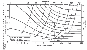
WAVE HEIGHT PREDICTION GRAPH
FOR COASTAL WATERS
State of Sea Card (part 1)
The two images below represent fairly large downloads
and may take some time over a slow connection
.jpg)
State of Sea Card (part 2)
.jpg)
The uk.sci.weather FAQ available at:
http://www.booty.demon.co.uk/metinfo/uswfaq.htm
the associated Glossary at:
http://www.booty.demon.co.uk/metinfo/glossary.htm
access to these and other meteorology related FAQ's via:
http://www.booty.demon.co.uk/uswfaqfr.htm
(many will find this latter url the most convenient one to use)
Calculate
Sun/Moonrise and Sun/Moonset at your location.
![]() Another daily forecast for
Another daily forecast for
North-East
Scotland is available
from Online Weather Interface
Also available are daily
forecasts for many towns and cities in the British Isles including:-
Lerwick
Kirkwall Aberdeen
Inverness Aviemore
Dundee Glasgow
Edinburgh